- Hotels
- Rent-A-Car
- Routs
Cambongo River/Negunza
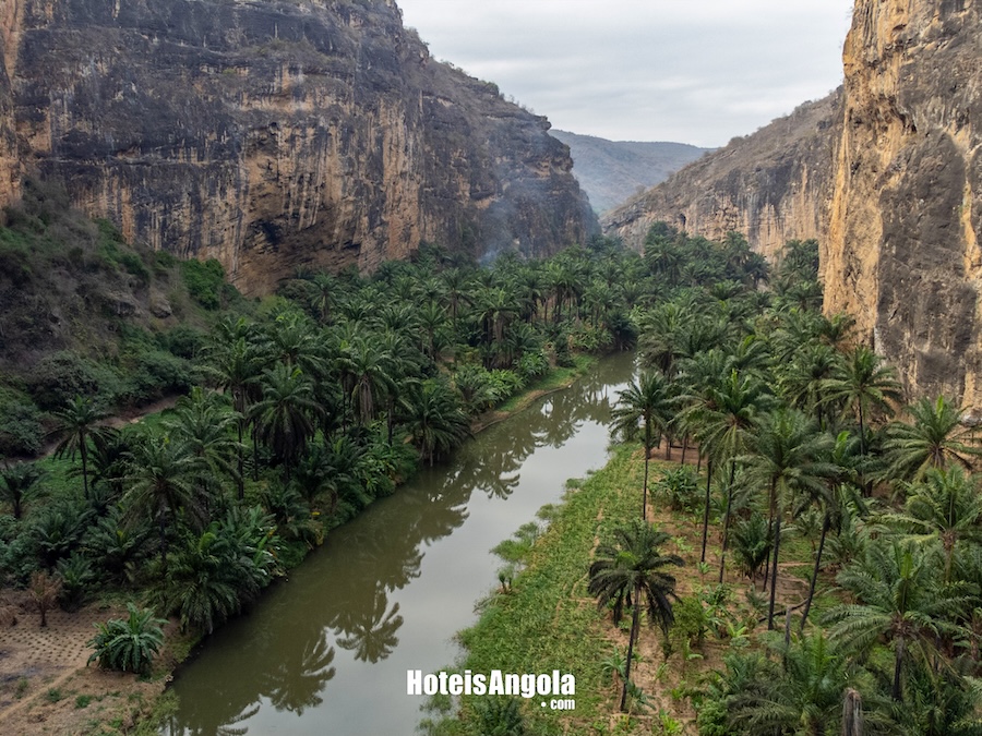
The Cambongo river, also known in its final section as the Negunza river, holds a unique history in its path for Sumbe and Angola. Next to its current stands the old Sassa dam, a structure that once fed a small power plant
In the same way, this occurs with other rivers and their main tributaries, as is the case with the two between which the Cambongo-Negunza basin is located, the Cuvo-Queve to the north and the Cubal-Quicombo to the south. The enormous complexity of the river courses is evident both in the coastal sector, closer to the Ocean, where the elements of the Cambongo-Negunza basin cross a strip about 28 km wide of Mesozoic and later materials of the Sedimentary Margin, and in the interior, much more extensive, of Precambrian, metamorphic, and eruptive rocks of the Ancient Massif.
From its sources in the Marginal Mountain massifs (altitudes over 2000m), the river descends along a staircase of flattenings to the sea, passing through a section of valley incised in sedimentary rocks.
In the various sectors, most of its tributaries also reveal courses dictated by tectonic structures, fractures, and faults, generally forming orthogonal networks.
Long almost straight stretches of the Cambongo-Negunza River are further evidence of these influences (Cretaceous–Quaternary).
The coastal flattening surface, including uplifted beaches (altitudes around 40 to 100m), cutting across the terrains of the Sedimentary Margin and the Ancient Massif, rises gradually eastward up to a well-marked topographic limit, the base (altitudes around 280 to 300m) of the western foothills of a NNE-SSW quartzitic ridge with an asymmetrical cross profile – the Engelo mountain range, with altitudes between 1,400 and 1,700m – also featuring faults, highlighted by thermal water springs.
From that coastal surface, in the zone of crystalline rocks, some residual reliefs emerge with characteristics of inselbergs or monadnocks, raising several issues, such as the westward extension of the quartzitic formations and their disintegration, and the behavior of these same materials in the complex processes of genesis and evolution of the extensive regional N-S escarpment line against which the flattened surfaces of the coastal margin terminate.
In the limestones near the coast, the Cambongo-Negunza River follows an underground course through large galleries and caves, re-emerging just before the small terminal plain.
Not far from its valley, dolines of various sizes and lapiezed surfaces can be observed.
The climatic conditions indicate semi-aridity: annual precipitation is less than 700 mm, evaporation is high, and the vegetation cover consists of a mosaic of savannas, steppes, and xerophytic balcedos, with scattered trees or none at all.
From its sources in the Marginal Mountain massifs (altitudes over 2000m), the river descends along a staircase of flattenings to the sea, passing through a section of valley incised in sedimentary rocks.
In the various sectors, most of its tributaries also reveal courses dictated by tectonic structures, fractures, and faults, generally forming orthogonal networks.
Long almost straight stretches of the Cambongo-Negunza River are further evidence of these influences (Cretaceous–Quaternary).
The coastal flattening surface, including uplifted beaches (altitudes around 40 to 100m), cutting across the terrains of the Sedimentary Margin and the Ancient Massif, rises gradually eastward up to a well-marked topographic limit, the base (altitudes around 280 to 300m) of the western foothills of a NNE-SSW quartzitic ridge with an asymmetrical cross profile – the Engelo mountain range, with altitudes between 1,400 and 1,700m – also featuring faults, highlighted by thermal water springs.
From that coastal surface, in the zone of crystalline rocks, some residual reliefs emerge with characteristics of inselbergs or monadnocks, raising several issues, such as the westward extension of the quartzitic formations and their disintegration, and the behavior of these same materials in the complex processes of genesis and evolution of the extensive regional N-S escarpment line against which the flattened surfaces of the coastal margin terminate.
In the limestones near the coast, the Cambongo-Negunza River follows an underground course through large galleries and caves, re-emerging just before the small terminal plain.
Not far from its valley, dolines of various sizes and lapiezed surfaces can be observed.
The climatic conditions indicate semi-aridity: annual precipitation is less than 700 mm, evaporation is high, and the vegetation cover consists of a mosaic of savannas, steppes, and xerophytic balcedos, with scattered trees or none at all.
Cuanza Sul, Angola
Map
Alojamento
Cuanza-Sul surrounding area
- from kz 49,000Emirais Hotel Spa
- from kz 59,910Hotel Kalunda
- from kz 46,800Hotel Ritz Sumbe
- from kz 27,000Hotel Ritz Waku-Kungo
- from kz 24,000Hotel Aanisa Ritz
- from kz 25,000Hotel Fazenda Cabuta
Support Line
 WhatsApp
 Telephone
 Email
Email
Available every day from 8:00 AM to 10:00 PM. Allows you to clarify doubts, support reservations, and guide you in choosing the best accommodation and tourist services.